Manchester - The Drowned Village
Manchester, so much to answer for – High Street and the Drowned Village
By George Kitching
It was last orders for the Dun Bull Inn in 1935. When the bell rang time it didn’t just mark the end of drinking hours but the end of days for the small farming village of Mardale Green. The Manchester Corporation had bought the land and was busy constructing a dam on the lake to flood the valley and provide a reservoir for its burgeoning municipal population.
A rural community hundreds of years old was to be broken up and consigned to a watery grave; its residents dispersed; their homes razed by the explosives of the Royal Engineers; their ancestors exhumed from their graves and reburied ten miles away in Shap; their church dismantled stone by stone and used to build a water take off tower for the reservoir. There would be no compensation beyond a sum paid to the Diocese of Carlisle for the church.

The dam itself was considered a feat of modern engineering but it’s hard to imagine the locals saw it that way. They must have wondered why they should give up their homes and their history for the sake of a distant city they had little connection with. Morrissey wrote Suffer Little Children about the Moors Murders but Mardale residents might have identified with the sentiment, “oh Manchester, so much to answer for”.
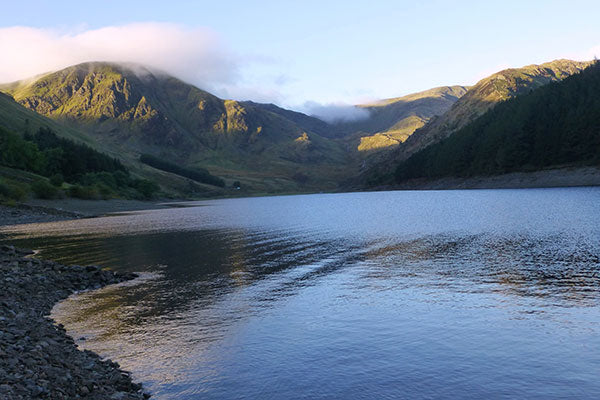
Today Mardale Green sleeps beneath the tranquil surface of Haweswater, the most easterly and secluded of the Cumbrian lakes; a place of spectacular natural beauty despite the artifice in its construction. It's hardly an unbroken slumber however: as has happened several times in the intervening years, when rainfall is low and the waters recede, the spectre of the sunken village emerges to remind the world what happened here.

When we visited in 2001, the rocky crags above the western bank were home to England’s only pair of nesting golden eagles. We made our way to the RSPB hide and were greeted by an excited steward who steered us to a telescope in time to see the male perched majestically on the cliff as the female circled. In Scotland they call buzzards “telegraph eagles” in honour of every tourist who's seen a buzzard on a telegraph pole and sworn they've spied an eagle; but when you witness the magnificent six foot wingspan of the real thing, there can be no doubt you're in the presence of a king among birds.
The female died in 2004 (the eagle, not the pushy American) leaving the male, known locally as Eddy, to lead a solitary and celibate existence. Sadly he has failed to appear since November 2015 so with each passing month the fear grows that our last surviving English eagle must now too be dead.
Haweswater teems with wildlife however. It’s a nature reserve where red deer, red squirrels, peregrines, buzzards and mountain birds such as the ring ouzel can be spotted. For all that, the Dutch exchange students who visit for their studies invariably stare awestruck at the hills; and it’s the hills that draw me back here too.

At 2,718 ft, the wide whale-backed ridge of High Street is the highest point east of Kirkstone. So named for the road the Romans built along its long flat top to connect Ambleside and Brougham, High Street is a grassy ridge to the north and south but to the east, above Mardale Head, it is a precipitous cliff descending dramatically to surround the volcanic crater of Blea Water, creating a natural amphitheatre not unlike Helvellyn and Red Tarn. Alfred Wainwright described the ascent from Mardale as “the connoisseur’s route”. This was my first fell walk, seventeen years ago, and one I love to repeat.
Starting from the car park at the end of the shore road, follow the path round the head of the lake and up to the Rigg, a wooded promontory jutting out above the drowned village. Turn left before the tumble-down wall and begin the steep ascent of a long ridge over the beautifully named Swine Crag, Heron Crag and Eagle Crag (which appropriately is exactly where we saw the eagle perched). The views over Haweswater, Riggindale and Kidsty Pike are superb and only improve as you gain height along the spine of Rough Crag, with the blue expanse of Blea Water an impressive vista to your left. After the marshy depression of Caspel Gate, with its own tiny tarn and bad-weather (or weary-leg) escape route to Blea Water, begin the final scramble to the top, climbing the aptly named Long Stile.

In contrast to the rugged, rocky drama of the ascent, the summit is a flat grassy plain traversed by a dry stone wall. Close your eyes and imagine the fairs held here in the 18th and 19th centuries where Cumberland and Westmorland wrestlers locked arms and farmers raced their horses – the top is still known as Racecourse Hill. Go back further and picture the cohorts of Roman Legionaries marching between forts. Most Lakeland peaks were remote, secluded spaces but High Street was a hive of activity. Today if you hear the sound of heavy boots coming towards you, it’s trekking poles not spears they carry and Goretex rather than armour plate they don for protection. If you hear a neigh or whinny, cast an eye out for the wild fell ponies that sometimes graze here.
Look north-west then slowly track around to the south to see a procession of celebrated Lakeland summits: Skiddaw and Blencathra, St Sunday Crag, Fairfield and the Helvellyn range, Great Gable, the Scafells, Bow Fell, Crinkle Crags and the Coniston Fells. To the south springs the distinctive skyline of the Kentmere peaks and the next section of the walk is shared with the popular “Kentmere Round” which circuits the neighbouring valley.
From the trig point, follow the wall then veer off left on the path to Mardale Ill Bell, from whose summit you descend to the Nan Bield Pass. This was the old packhorse route linking Mardale and Kentmere but is now the preserve of ramblers and mountain bikers. The views on both sides are unforgettable and the pass itself sports a large stone shelter which offers a good windbreak for a rest and revitalising snack before the final pull up to the summit of Harter Fell with its strange cairn made from old iron fence posts. Descend via the Gatescarth pass back to the car park.

As you drive away along the shore of Haweswater, spare a thought for the submerged village of Mardale Green and the golden eagles that once soared here. Shot, trapped and poisoned to edge of extinction by farmers and gamekeepers fearing for their lambs and game birds, conservation efforts now abound to encourage them back; but as Natural England issues new licenses to shoot buzzards, I wonder what lessons we’ve really learned; as Otis Redding sang: “You don’t miss your water till your well runs dry” - a lyric with an ironic twist in Mardale.